
In a previous blog I stated that “all” of the Netherlands is below sea level. Well, that was a 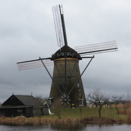 bit of an exaggeration that I will correct with this entry. I looked it up – yep, I googled it – just to get a fact or two straight. Per Wikipedia 1 (whatever did we ever do without Google and Wikipedia?), about 20% of the total area of the Netherlands is below sea level with about 50% of the land being less than 1 meter (about 3.28 feet) above sea level and 21% of the population living below sea level. There is a mountain named Mount Vaals (Vaalserberg) that is 322.7 meters (1,059 feet) above sea level. Mount Vaals is shared by Germany and Belgium so it is not totally within the boundaries of the Netherlands but it does mark the high point for that country. To give you some perspective on that, Mount McKinley in Alaska (highest point in North America) is 6,194 meters (20,320 feet). Closer to home here in Maryland, Sugarloaf Mountain is 391 meters (1,282 feet). So, if you have visited Sugarloaf, you can imagine that it is slightly higher than the highest point in the Netherlands. And Mount Vaals is not representative of most of the landscape in the Netherlands…there is a reason the Netherlands are call the Low Countries. Most of the land that we saw on our recent visit was below sea level or just at sea level and all of the towns visited were filled with canals and dikes. It was definitely a case of “water water everywhere”. So what do you do if all, or most of the land, available for living and farming, is either underwater or very, very wet? If you’re in the Netherlands, you build dykes and you harness the wind to help you move as much as you can. Which
  brings us to two of the three reasons anyone might visit the Netherlands, namely to see windmills, check out the dams and dykes, and to see tulips. I am sure there are other reasons to visit, maybe buy some diamonds, but, for me, these are the big three – windmills, dykes, and tulips. And if you want to see windmills, you go to the UNESCO historical site Kinderdijk where there are 18 windmills still working and you can learn everything you ever thought you might want to know about them.
Before I go further, this blog is not intended to be a tutorial and I am certainly not the authority on anything related to the Netherlands or my big three interests from my visit there. I only share some of the things I learned from the trip, most of it gleaned from the information provided by the various tour guides and from my aforementioned sea level data check using Google and Wikipedia on the Internet.
Growing up in the south, I am very familiar with grist mills and have visited a few that are preserved – some still working grinding meal for tourists to see — over the years. I suppose, in my mind, I associated windmills with grist mills and somehow figured that windmills would be pretty much the same. Of course, that is nowhere near the truth. Grist mills in the US are water driven mills whose function is to grind grains, mainly corn, into meal to be used for cooking bread. But windmills in the Netherlands use the wind to power screw technology to move water from one area to another. About the only similarity is that the mills use natural power sources, wind or water, to provide the power. I do believe the Dutch also used a type of windmill to grind grain but they mainly used windmills to remove water. And they were doing it from way back in the 13th century.
 But, back to windmills…..as noted, as early as the 13th century, windmills were being used to pump the water from one area (usually a lower lying area) to another area (a river or lake). The land that was created is a polder which seems to be an island that is below sea level. As more land was cleared, the polders became bigger. A row of windmills would be built on the dykes to keep the water cleared from the polders. As one canal became filled with water and prone to overflow, another row of windmills would be built at a higher level with another canal or man-made lake until the water could be pumped to the main river and eventually out to sea. As such, the windmills are built on tiers of land so that the water is gradually raised to the sea level and can flow out to sea. Although the old windmills are not used today (except those at the UNESCO site at Kinderdijk) for this purpose, there are modern pumping stations that still use the old Archimedean Screw 2 technology to keep the land dry. Essentially, the technology involves the use of a very large screw which is placed inside a hollow pipe. The whole thing is placed in the water on an angle with the bottom of the screw in the water and the top of the screw at the higher level where the water is to be dispensed. As the screw turns, the water is pulled into the bottom and moves up the screw until it comes out at the top.
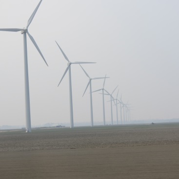
 While the Archimedean Screw is still used for pumping water, the windmills are not. The industrial revolution brought in the use of steam engines and, now huge diesel engines provide power to the pumping stations. But, with all the wind still readily available for use in the Netherlands, no one has given up on the use of windmills. They just changed the design and function. Huge modern steel windmills dot the landscape generating electricity. Having used windpower for hundreds of years, it was probably a no-brainer for the Dutch to graduate to generating electricity using the technology….and from the number of windmills in the countryside, I do not believe there was as much controversy about using the new windmills in the Netherlands as there has been in the US.
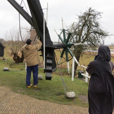 One final thought about windmills. Like lighthouses where the keeper lived inside the lighthouse, the miller also lived inside the windmill. The accommodations were pretty tight and pretty rustic considering that the parts of the windmill pretty much filled the windmill. The windmills at the UNESCO site are also inhabited by the “millers” who operate them. However, I do not believe the millers actually live solely within the windmills; I suspect that the furnishings we saw in the windmill were for our benefit and the miller and his family live in the outbuildings nearby. The guide told us that there are 2 professional millers at Kinderdijk and the rest were in training. She mentioned that there was a waiting list to become a miller and to live in the mills and operate them. We were lucky enough to see a windmill operating (at tremendous speed) and to see the miller come by to stop the mill before he left for the day.
 Okay, that’s windmills but what about those dams or dykes? The Dutch had “water management councils” or waterschappen from as early as the 12th century. We were told that the “water manager” for a town was much more important than any other Government official for the farmer’s livelihood and even the lives of the people depended on the keeping the water at bay. The mayor might have thought he was the big cheese but he pretty much did what the water manager told him to when it came to the dykes and the windmills and keeping the town dry.
Basically, water management consisted of the dikes, canals, and pumping stations (windmills). The earliest water management methods consisted of trying to block the water from coming in from the North Sea and the Zuiderzee or Southern Sea. At first, I think it was a case of a little here and a little there…..block this stream, build up that bank, add a little dirt here and a little there. Smaller and simpler dams were built in the beginning and made bigger and stronger as time passed. Dykes were connected to create much bigger dams. Canals between the dykes were built to allow water to flow out at low  tide but blocked to prevent water from coming in again at high tide. Dams were high ground so people settled and built their homes on the dams. And so you have Amsterdam which was built on the dam on the Amstel River. And, yes, that is the river which has a beer named after it. Similarly, you have Rotterdam which was built on the dam(s) on the Rotter River. In Amsterdam, the main part of the original dam is called the Dam Square. And all the trams run through it and all the tour groups meet there. After a long day of walking on uneven cobblestones, it is not unusual to hear the tourists walking around lost going up one canal street after another looking for that “damned square”….then again, maybe it was just me that said that.
Clearly over the years the bigger issue was not allowing the water to go out to sea with the low tide but stopping it from coming back in with the high tide. And over the years, the dykes failed and had to be rebuilt which was made more difficult because every time the tide came in while the dyke was being repaired, it breached the dyke again. This went on for centuries. And each time the land was flooded with salt water, it took years for the land to become suitable for the plow and growing crops again. I found myself wondering if this is why the Dutch say that they “reclaim” the land implying that they had to keep clearing the same land of water over and over again. The 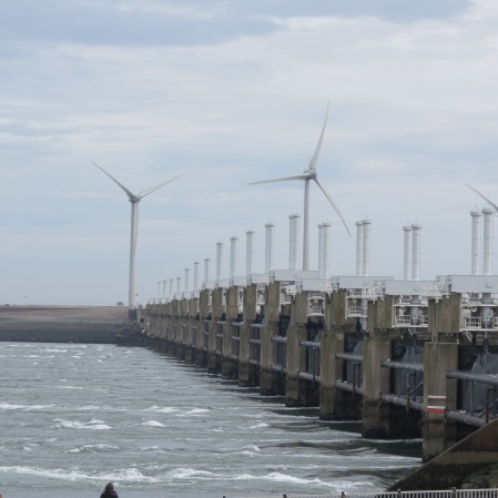 last big natural flood was in February 1953. Prior to that some areas of the southwestern part of the Netherlands were flooded by the Allies in their efforts to stop the advance of the Nazis in World War II. I’m sure it made sense to the Generals and tacticians to breach the dykes and flood the land but it must have been devastating to the people trying to survive anyway to have their farms and fields flooded leaving them without homes during this war. Then, less than 10 years later, they’re flooded out again with hundreds lost and drowned when natural forces broke the dams.
Today, there are two main systems of dykes in the Netherlands. The Zuiderzee Works on the Zuiderzee (Southern Sea) in North Holland and the Delta Works in South Holland and 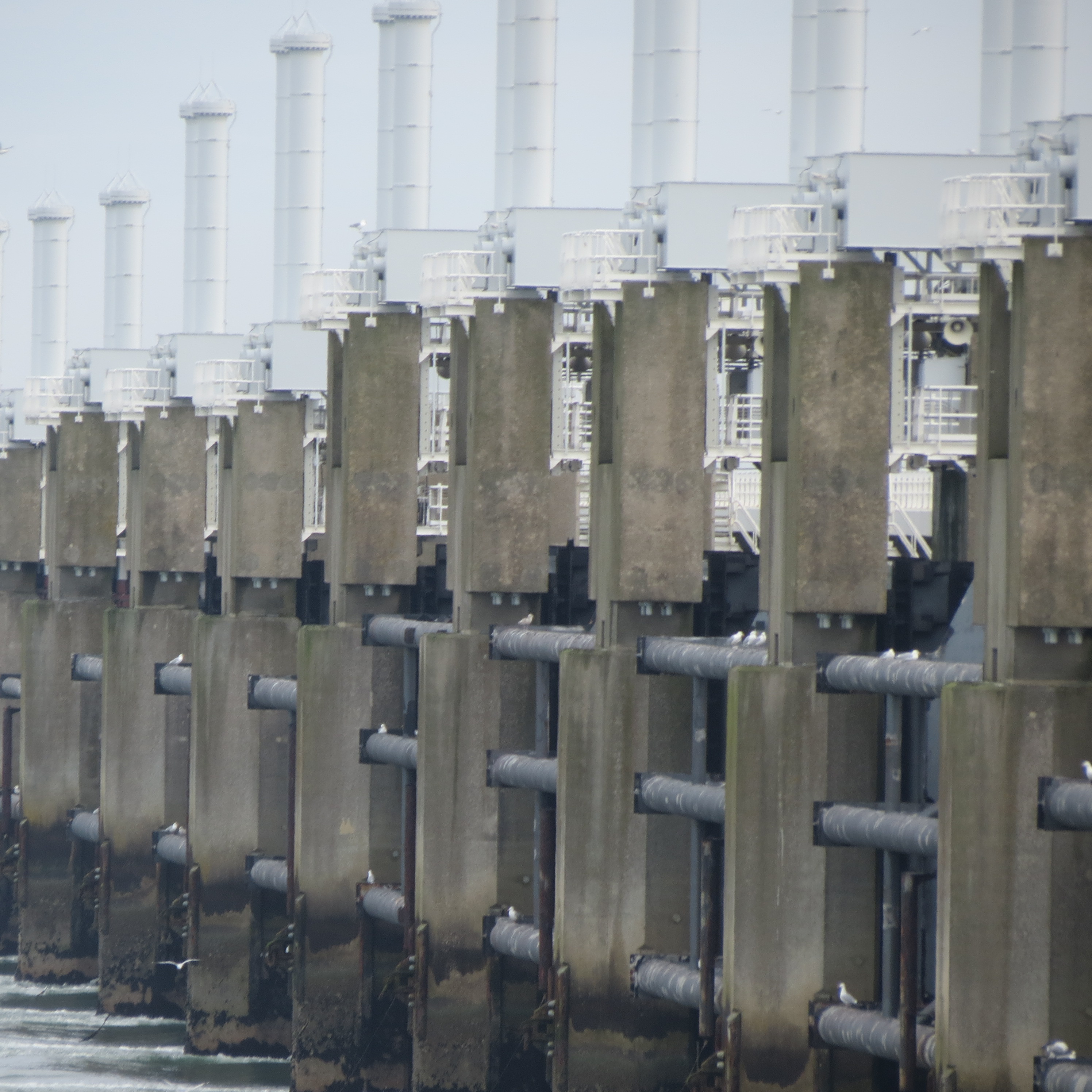 Zeeland. The Zuiderzee Works was built in 1932 in the north and created the IJsselmeer (IJssel Lake). Interestingly enough, we were told that the water in the Ijsselmeer is fresh water and that closing the lake off to the tides of the Zuiderzee effectively destroyed the fish and seafood industry in that area. The water runs into the lake from the rivers and streams and is carried out to sea with the low tide but blocked from returning with the high tide so it remains essentially fresh or only slightly briny. The Delta Works in the south was begun in 1958 and finished in 1997. It was the Delta Works dykes that we visited and photographed. You can see on the photograph included that the dykes consist of a series of gates that can be opened in different combinations to control the flow of water into and out of the area.
While we were touring these areas, I just could not help thinking of the islands in the Chesapeake Bay that are slowly being eroded away and wondered if the Dutch would not have taken a different perspective on whether or not to let nature take its course. I also pondered whether or not New York City and particularly Manhattan Island would be the metropolis it is today had it been originally settled by some group other than the Dutch East India Company. It is 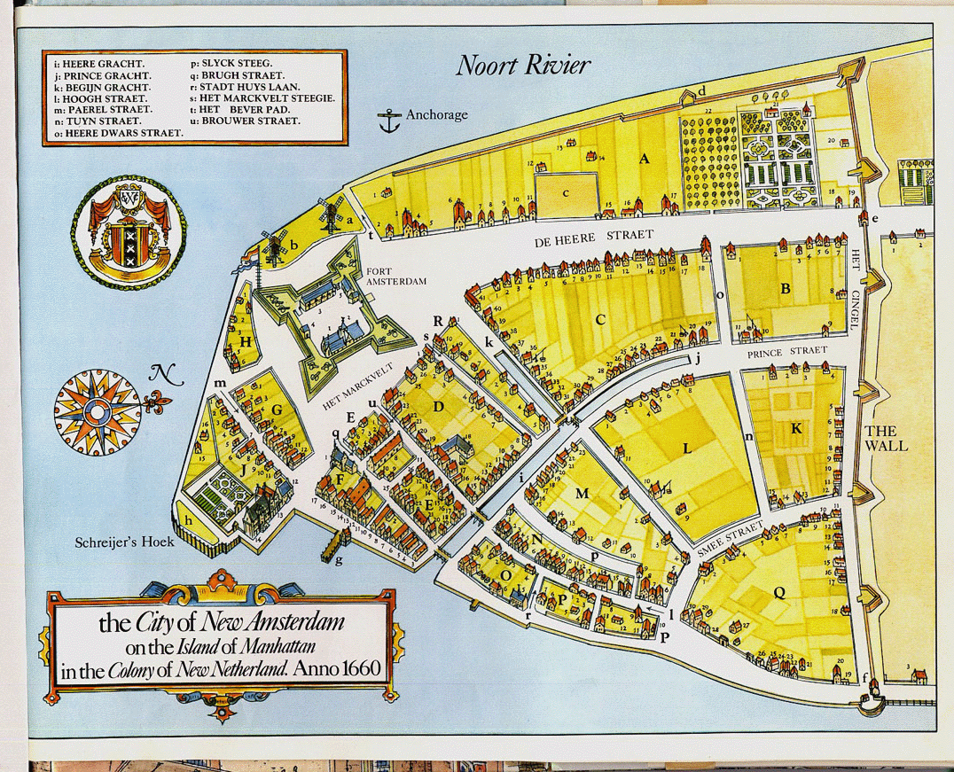 my understanding that the southern end of Manhattan Island was originally very swampy and prone to floods of the surrounding rivers. Where other colonists might have seen too much swamp and not enough landmass, the Dutch were probably not the least bit put off by the marshes and wetlands. They had access to the Native Americans for fur trading and access to the sea for shipping the furs….what better place to build a town. I found this photo of an old map on line – check out the canals — of course they would build canals; it was technology they knew well. And they called it New Amsterdam, what else?
If you’re still interested and looking for way more information on dams and dykes and windmills –
