

When I was a child, I slept in what my family called the “middle room” with two of my sisters. The middle room was a bit oversized for our humble home with three large windows centered on one side that overlooked one of mama’s many flower beds. The room had three twin beds evenly spaced across the room with the middle bed centered on the center window. Mom had bought three bedspreads from one of the traveling salesmen that came through the area occasionally – two blue and one red, otherwise the spreads were identical with some sort of satiny material that I thought was just too special and, of course, made my bed seem like it was fit for a princess and not the “tom boy” that I usually was. (For the record, my older sister and I had the blue spreads and my younger sister got the red.)
But this memory is not about the bedspreads. It is about a print that hung high on the wall in our bedroom. This was before Better Homes and Gardens or some such magazine clued us in that pictures should be hung at eye level to better enjoy them. Or, maybe it was just that I was small and the picture seemed like it was hung high up on the wall to me. But it did seem like it was positioned almost up to the ceiling of the room and the print was faded to a soft green so that I could not quite tell what it was a picture of…but I could see there was a huge rocky cliff and maybe a pond or lake. The viewpoint was as if you were standing right at the edge of that water with it almost lapping right up onto your toes. The solid rock cliff was huge and took up most of one side of the whole scene. And, no matter how I squinted and tried to make out the rest of the picture, I just could not tell what was on the other side of that water…..more mountains, I think. The print was just too faded for me to see much more than an echo of the original scene.
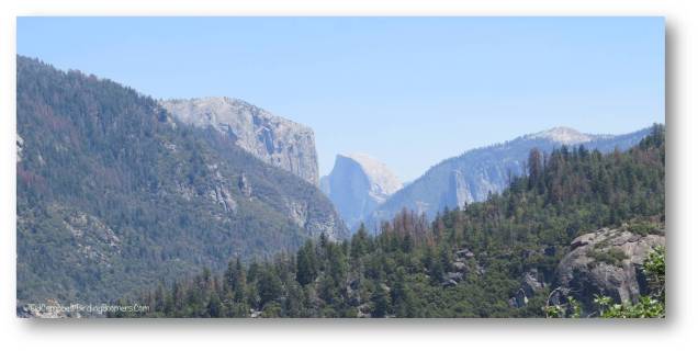
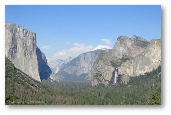
First look at Half Dome and El Capitan from CA Highway 40.
Over the years, I forgot about that print but I think maybe that might have been an old picture of Yosemite National Park that was maybe cut from a magazine or book and framed and somehow ended up in our house and, ultimately, in my bedroom. I cannot be sure but it seems possible. So, years later, I decided I wanted to go to Yosemite someday and see if maybe there was something in the park that matched my memories of that print. Now, y’all all know children’s memories are not great no matter how good they are and it is entirely possible that the faded print was one of those pictures of the little girl standing on the shore of a pond being watched over by an angel that is so popular and that hangs in just about every poor family’s house in the Bible Belt in the south. But I got it into my head that it was Yosemite and I wanted to see that place so that’s the memory I’m sticking with….at least for this blog.
Well, someday finally got here and I finally got to go to Yosemite. And, as we roamed around checking out each attraction in the national park, I tried to imagine if it fit into the scene of that picture on the wall that was in my head. But after a bit, I got over all that. Yosemite is so full of beautiful things to see that I quickly stopped trying to placate an old memory and just concentrated on enjoying myself….and ignoring the masses of people who had all decided to visit the park exactly when we were visiting the park. Now, I’m not saying they all came there just because I was there but sometimes I have to say that it feels like people are following me around where ever I go.
Nope, chalk it up to planning and happenstance. Every year something like four (4) million people visit Yosemite and almost all of them visit in the summer. It makes sense because the park is in the mountains and pretty much snowed in most of the winter. Even if it isn’t snowed in (yes, it is open for business in the winter too), it is pretty cold and most people do not want to spend their time looking at frozen waterfalls and hiking in snow in freezing temperatures. Yes, there are some who do and we will leave them to it, as far as I am concerned. So, if you limit the available time for visiting the park in good weather to maybe four (4) months – June, July, August, & September, it doesn’t matter how you spread out 4 million, it always works out that you’re gonna be crowded and aggravated by someone getting in your way…..and into almost all of your photographs of waterfalls and granite domes and other famous attractions.
So planning is dicey. I planned many months ahead but still could only get lodging reservations in the park for about four (4) nights in July. We would have preferred May or later in September but the cooler (but not frost-bitten) times get booked up quickly. There is the alternative of staying outside the park (more lodging, not necessarily less expensive) but then you have to deal with the hour plus drive (or shuttle) each morning into the park…not to mention going home exhausted in the evening. And then there is parking inside the park….of which there is quite a bit but none available by maybe 9:00 AM. So we opted to try to get lodging in the park but, as noted, had to take what we could get…..and that was July.
While I’m on parking, the park provides a shuttle service to all the sites in the park on what they refer to as the “valley floor”. When most people think of Yosemite, they think of Yosemite Valley (about 5.9 square miles) although the park totals 1169 square miles (747,956 acres) and has miles and miles of hiking trails stretching all over the Sierra Nevada mountains. But most of the attractions people go to see are either in the valley or in the mountains surrounding the valley. As I mentioned, parking is crazy. Even if you are staying in one of the lodges or camping areas, there is no guaranteed parking. So pretty much, everyone just drives around and around the parking lots until someone else leaves and opens up a space. If you’re lodging in the park, you get that space and don’t give it up until you are ready to leave the park for good. The shuttles come in handy to allow you to get around. Yes, they are crowded beyond description and, yes, the main hiking paths are filled with people almost all day, and yes, the restaurants are overwhelmingly crowded…..but, yes, it is all worth it…absolutely…..although at the time, I did question my own sanity for being there in the most crowded season possible.
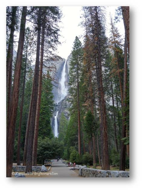
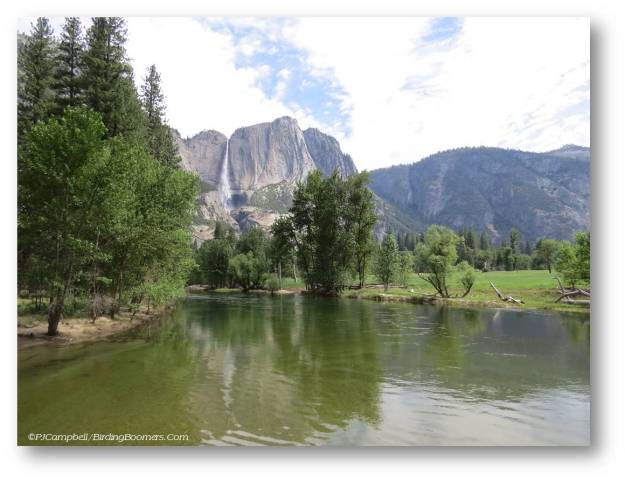
The absolute best time of the day was early evening when the tour busses and day-trippers start to leave the park and the walking paths clear and things cool down and the restaurants clear out a bit. We found ourselves strolling along the path up to Yosemite Falls one evening and had the place pretty much to ourselves. We were free to take photos of the views and only us – no accidental photobombs. The path was clear so I could stop and rest in that one spot where you can actually see and get photos of all three falls – Upper, Middle, & Lower – that make up the total falls.

And we were so blessed that there was still plenty of water in the falls which are fed by snowmelt each year. When the snow has all melted, the falls have been known to become just a trickle skimming down over the rocks. But, the winter of 2017 was amazing (so I hear) when it comes to snowfall. We were to learn later over in Mammoth Lakes that they got more than 116 inches of snow this year. It made for some beautiful waterfalls in Yosemite and the Sierra Nevada mountains.
Just a bit more on the waterfall…Yosemite is the 5th tallest cascade in the world at 2,425 feet and the tallest in North America. Sentinel Fall in the park is the 7th tallest in the world at 2,000 feet. In case you’re wondering, the tallest waterfall in the world is Angel Falls in Venezuela topping in at 3,212 feet. The one waterfall in the valley we could only admire from a distance was Bridalveil Fall which has a 620 foot drop. The Ahwahneechee natives called it Pohono which means “Spirit of the Puffing Wind”.
We did get to see the falls from the Tunnel Pass Overlook and got to see the mist fanning out by the wind and creating a rainbow. We tried on several occasions to get to the falls to hike up to the base for a closer view but could never even get into the parking areas. Bridalveil is one of the first attractions that visitors come to on the road as they drive into the park; hence, it is always way over-crowded. Unfortunately, it is also the one attraction in Yosemite that you cannot reach by shuttle bus (and a little hiking) although I cannot fathom why it is not a stop on the El Capitan shuttle route.
Because there is so much to see in the park and things were so crowded, we decided early on that there would just be some things we would not get to see or fully experience and we would just have to leave it at that. It is what it is or, in this case, was what it was.

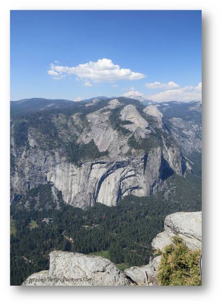
But we did get to see quite a bit. We took the Glacier Point Tour leaving the driving up the mountain to someone else who knew just about everything there was to know about the park and its history. The tour took us to the top of Glacier Point which gives beautiful and awe inspiring views of the entire valley floor. The view of Half Dome was amazing. It is right there in front of you at Glacier Point. No, there are no glaciers there; the point just gives a very good overview of the valley and allows you to see how glaciers formed the valley in the last mini ice age.

On the way back from Glacier Point, we stopped at Tunnel View (formerly Wawona Tunnel) to get another look of the valley from the western end with El Capitan, Half Dome, and Bridalveil Fall taking center stage and making for beautiful panoramic photos (and allowing everyone to use all the features on their cell-phones instead of just the “selfie” mode). And, yes, there is a tunnel at Tunnel View.

Oh my, I could go on for page after page about the days we spent at Yosemite. Mirror Lake did have water. That is slowly changing. The lake was formed by a rock slide years ago that dammed up one end of the creek. The park kept the lake dredged and cleared for many year since this was (and remains) a popular tourist attraction. But some years back, it was decided to let nature take its course so now the lake is silting up and the original rock dam is no longer holding as effectively as it did in the past. So the lake is becoming smaller and smaller and reflecting less and less. But the walk, while strenuous to us (not to all those younger and fitter people who kept passing us at a good clip), was enjoyable. And the view once we got to the top was beautiful. It was somewhat crowded at first and any chance of getting a good reflection of Half Dome in the lake’s “mirror” surface was slim because kids were having a wonderful time wading and swimming in the shallow lake….and who can possibly complain about kids having a good time cooling down after the hike? We sat for a long time just enjoying the scenery and doing a little birding.

By the time we headed back down the trail, we were pretty much the only ones there. It was so very peaceful and so very beautiful….and walking downhill is always better. AND, we saw a bear! It was just a bear cub – he was adorable – but we did get concerned that mama was somewhere about so we did not linger or try to get too close to him. Later, we asked a ranger about this bear that was ear-tagged with number 23, and he told us that this was a second year cub that was on its own now…so no worries about a big mama bear ruining our pictures…..or, any of our body parts. They had just tagged him a week or so ago and they were keeping an eye on him to make sure he (or the humans trying to gawk at him) did not become a nuisance. As long as the little guy grazes on berries and natural foods found in the park, he was all good; tempting junk food supplied by humans or improperly disposed of….not good. You should have seen the bear-proof garbage cans – just learning to throw trash away was a feat unto itself.

Bent Tree. Actually, I call this “Life will find a way”.
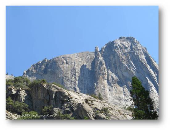
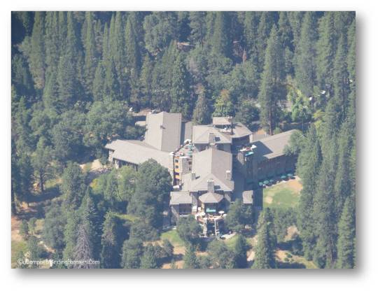
Wow, what else? Great things – the waterfalls, Half Dome, El Capitan (largest piece of exposed granite in the world which stands about 3000 feet from base to summit), watching climbers on the rocks while we walked at Happy Isles, Merced River running right through the park, a lovely morning walk through the meadow and views from the Swinging Bridge, the rushing clear-water creeks coming down from the falls, exploring the Majestic (Ahwahnee) Lodge & having dinner there, the delightful little collared ground squirrels that were simply everywhere, our time chatting with the nice young lady at the Majestic who has worked there for a few years now and lives year-round in a tent at Half Dome Village, seeing the field of lavender wildflowers as we entered the park from Highway 140, the absolutely marvelous star-gazing tour we took with a very star-crazy ranger, and the ever present and noisy Steller’s Jays (a lifebird for us!) one of which attended every meal possible with us no matter where we dined. The list is really quite lengthy and I could go on for hours about the things we saw….not to mention showing you each and every one of those five hundred or so photos that I took just inside the valley. Yep, if there was a rock or a flower to see, I took a picture of it.

On the bad side? The crowds were terrible. Weekends were the worst. Do not go to Yosemite in July. It was way too hot in the Valley – California was in a drought and having a very hot summer. It was in the high 90’s and low 100’s every day we were there.
The lodging was expensive and marginal. The rooms are not air-conditioned and, with the heat outside, they were stifling during the day and into the night. A few years ago when we went to Costa Rica and stayed in eco-lodges (no A/C although they didn’t have problems with the ecological downside of large swimming pools which were lighted into the night), I learned to wrap a damp towel around my neck at night to help me sleep. This method of staying cool also worked in California.
The shuttles are a good idea and were great except when things got crowded; then the shuttle drivers would make decisions not to stop at a given stop on the loop or even to go to a particular shuttle stop so it was possible to find yourself waiting a very long time to get picked up….or, waiting a very long time only to find you couldn’t get onto the shuttle when it finally arrived. They were supposed to run about every 20 minutes but that was on the low side of reality while we were there. Like many people, sometimes we just walked if the distance wasn’t too far.
The food and food service was blah…except at the Majestic Lodge where they actually seemed to have chefs. We were told that most of the food venues did not actually serve food that was prepared at the site; most all of it is trucked in every morning. And most of it wasn’t good at all….like bad vending machine food. The pizza was okay but everything else seemed to be warmed up….even when they had someone (supposedly) working the grill. We quickly got into the habit of going to the coolers and getting pre-made sandwiches…even for breakfast. It worked out very nicely though because we could take the sandwiches (and chips or fruit or muffins) to a nice spot along one of the trails and have a picnic. This worked out so well that we continued it for lunch at other parks that weren’t so crowded throughout our time in California. It seems to me that it is pretty difficult to mess up two pieces of fresh bread, a slice of lunchmeat and maybe a slice of cheese. Do note that I said “fresh” bread….which, fortunately, it always was. The Majestic, on the other hand, had good food…as you would expect in a high-end hotel with a nice restaurant. It was pricey though…..as you would also expect in a nice restaurant.

Finally, most of the hiking trails were just too steep so I feel like I missed quite a bit. I am not very fit and the altitude was a big problem for me. Some of the trails were purported to be “relatively flat” and they were…….as long as you defined that to be flat from side to side; otherwise, they pretty much went up at a steady vertical incline. Well, it is the mountains and waterfalls happen off the sides of mountains and don’t just gush up out of the flat ground. (That’s another park altogether.) So, pretty much I started tracking things I saw and then those things I didn’t see because I didn’t quite make it to the top of the trail for a few attractions. I did give it all I could but sometimes I needed to breathe so had to stop short of my goal. I try to remember my age and stay philosophical about it but, I have to tell you, I really felt bad when kids (anyone younger than 60) would pass me jogging (yes, I said jogging) up the trails and I would be sitting on a rock huffing and puffing like the little engine that couldn’t.

I did find out that, for those of you who are out-of-shape like me, you can stop in at the visitor center and tell them that you have trouble getting to some of the sites or maybe just breathing in the thin air and they will give you a handicapped pass for your car so that you can drive up to some sites using the service roads for those attractions that have service roads. You do not have to show any official handicapped stickers or permits……just have to ask. I wish I had known this before we hiked to Mirror Lake; it would have helped tremendously….but, then again, I might not have seen the little bear.
Would I do it again? If that park were anywhere but in California and it wasn’t mid-summer………maybe…..just kidding. Of course, I would certainly do it again. It was, as expected, the experience of a lifetime and, pretty much, too beautiful for words.
Did I find the vista from the print in my childhood bedroom? Well, I just don’t know. There were certainly quite a few beautiful scenes with huge rock cliffs (like El Capitan or Half Dome) and lakes (like Mirror Lake) that could work to be that scene in that picture. So, all in all, I’m still left wondering. (You know it still could be that angel picture too.) But now, I have lots of new photos to look at and wonder which might match the old faded green picture from my childhood. But, really….it doesn’t matter…….maybe they all do.
 Last days are for doing last things. But this time, the last day was an extra day. We had allowed more travel time to get back to Omaha from Burwell so we hadn’t anticipated having a whole day available for one last adventure in Nebraska…well, not only Nebraska.
 But, both the “loop” that’s now a lake and the steamboats on the river both play a part in the history of DeSoto Refuge which is the first of two refuges we visited on our last day in Nebraska. Because of the river and the locations where the bridges are built, we seemingly took the long way up to the Refuge – first in Nebraska, then in Iowa, then back to Nebraska…..seemingly for miles.
 But we got there all the same with no big problems. From the very start, we found birds. There are nice wetlands and impounds right along the entry road to the refuge and, although most migrating birds had left the area, there were still enough to keep our interest as we drove into the refuge.


 Remember that “loop” from the river that became a lake (Loop Lake, by name) in the refuge? Well, the back of the visitor center has an observation area built to overlook the lake making it very convenient and very warm in the winter to come and see the thousands of migrating waterfowl that come to the river and lake each year. Most had already headed north for their breeding grounds when we visited but, having spent many winter days shivering in the cold on a refuge watching Snow Geese and Tundra Swans, etc., I can tell you that a large, warm, glassed-in visitor center built right over the lake would be just the ticket for winter birding. As noted, I absolutely fell in love with that observation room…I really think Jerry thought I was a little bit crazy….but I’m telling you, warm birding in winter is way better than freezing birding….I’m just saying.


