In my last blog, ”Redcoats and Farmers and Birds”, I explored North Point State Park near Baltimore, MD. My original intent was to check out a local birding hotspot but it seems one cannot explore North Point without getting a little involved in the War of 1812 and, that is especially true this year because September 2014 is the 200th anniversary of the Battles of North Point and Baltimore and the writing of The Star Spangled Banner1 by Frances Scott Key. Well, if you’re gonna talk about Mr. Key and the poem (Defence of Fort McHenry) he wrote “by the dawn’s early light”1, then you might as well get right to it and visit Fort McHenry. So we did. And why not write all about it? So I am…and I am dividing my thoughts into three parts.
Part One: The Bombs:
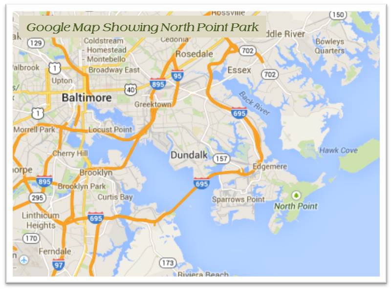
So in that last blog, the British were anchored off Baltimore and unloading troops at North Point and were heading up North Point Road while their ships bombarded Fort McHenry and the Baltimore Harbor. The British has just finished burning Washington and were heading in to do the same to Baltimore. One of the comments I received from that blog advised that the port city of Alexandria, Virginia on the Potomac just south of Washington, DC had elected to surrender to the British thereby preventing that lovely city from being burned. I suppose in a war you have those same two options – fight or flee – or, in the case of Alexandria, give up and live to fight another day. On the other hand, I found myself wondering about Annapolis – how did this city survive? The British ships would have passed right by on their way up the Chesapeake to Baltimore. It seems the British had bigger fish to fry and Annapolis just wasn’t on the radar (okay, considering radar hadn’t been invented yet). Baltimore was a much bigger prize if your intent is to give those dastardly Americans a good butt-kicking.
 But on to Fort McHenry – You are just going to have to check some of the links and read up on the war all by yourself. I am only giving you the quick and dirty version herein. Fort McHenry is located at a strategic point where the Patapsco River flows into the Chesapeake Bay. The city of Baltimore and its Inner Harbor are on a bit of a cove – the northwest branch – right at the conflux. Fort McHenry sits on a point looking out onto the Chesapeake. The entrance to the port is relatively narrow so the Fort with its big guns was very adequate to protect the inner harbor. Fort McHenry was defended using cannons firing 18, 24, and 36 pound cannonballs with a range of about one and a half miles. The British ships fired rockets and mortar rounds with a range of about two miles. So, of course, the British were anchored just about two miles away off Sparrows Point (about where the Key Bridge crosses today). It is easy to understand why Mr. Key was a bit concerned about the ability of the troops at Fort McHenry to successfully defend the harbor and why he kept watch through the night hoping to see the flag raised at dawn. At dawn the flag was raised and he wrote his famous poem. Here’s the quick and dirty part – the British were repelled and Baltimore survived the bombardment and are planning a big ole party called the Star Spangled Spectacular on September 10-16, 2014 to commemorate the battle and the victory.
 Just a few last thoughts on Fort McHenry and war. The original fort called Fort Whetstone was built in the Revolutionary War because the citizens feared an attack that never came. Fort McHenry was completed in 1803 just a hand full of years prior to the War of 1812. The fort was used for training for the most part during its active history but it is noteworthy that during the Civil War, the big guns were sometimes aimed at the city rather than away from it. I suppose some folks in Maryland didn’t want to remain a part of the union, had loyalties to the south and caused some problems in the city. I got this bit of info at the museum at the Fort but haven’t been able to confirm it on-line so take it with a grain of salt either way. I’m sticking with the museum info – it makes sense since, even today, I have found that the good people of Maryland cannot seem to figure out if they are southern or not. The 141st Coastal Artillery Company departed Fort McHenry in 1912 after 110 years of service there so technically, it was not an active fort anymore but during WWI, it was used as a hospital and, during WWII and a bit afterwards, it was leased by the Coast Guard for port security work. Now it’s a National Monument and open year round to tourists and, well, birders.
- The Star Spangled Banner: Lyrics – Frances Scott Key, “Defence of Fort McHenry”, 1814, Baltimore, Maryland, USA; Music – John Stafford Smith, “To Anacreon in Heaven”, 1775, England.

Part Two – The Birds:
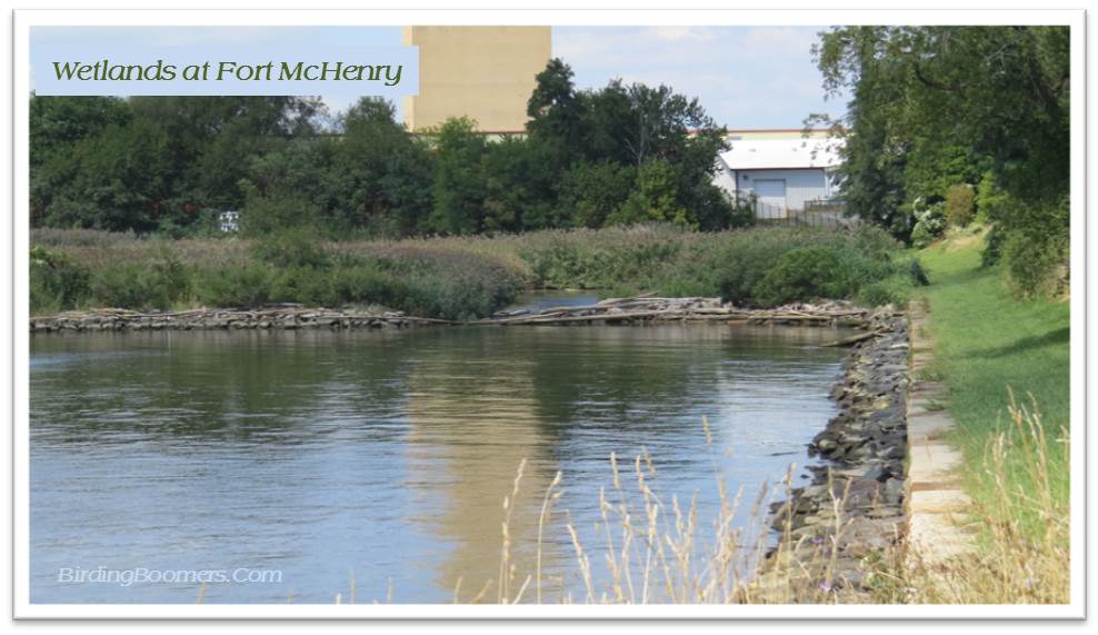
I started this latest quest to explore parks in and around Baltimore for the birding opportunities. Last May, we attended the Maryland Ornithological Society (MOS) Conference at Solomons Island, MD. During dinner one night, we were seated at a table with a couple of lovely ladies who were avid birders and members of the Baltimore Bird Club. I asked about birding in Baltimore and mentioned a couple places I had heard of like Robert E. Lee Park (yep, back to war again) near Jones Falls. I was surprised when one of the ladies mentioned Fort McHenry. Now, I had never been there but had this overall impression that it was a park with the remains of an old fort sitting up on a hill just outside the Inner Harbor at Baltimore. I just couldn’t wrap my head around the thought that someone would do some serious birding there. But I was informed that there was good birding there and I should go to the “back side” over in the wetlands. Wetlands at Fort McHenry? I just couldn’t figure that one out. So, there was nothing to do but go and see for myself. I heard about North Point State Park at the same conference although from a different source and that had turned out to be a great park for birding so why not Fort McHenry?
 So we went. And we learned a little bit (a very little bit) about the War of 1812 as evidenced by my summary above. (The information was available – I just didn’t learn it.) But we did find the wetlands. But that is where the good part ends. The small marsh on the back (southwest?) side of the peninsula was easily found at the end of the Sea Wall Trail but I could not find any way to actually access the wetlands. I have to admit summer is not the ideal time to bird in and around waterways so was not surprised that we didn’t see many birds at all in the park. The park is mostly mowed lawn with some trees but not many so it was not exactly prime habitat for birds from my perspective. I can imagine that there would be plenty of waterfowl in the winter in the harbor and the river so I would recommend that anyone going birding at Fort McHenry focus on wintertime birding. I think perhaps one could sit in the park overlooking the wetlands and do some birding with a good high powered scope but there do not appear to be any obvious trails through the marshy area although a ramshackle bridge can be seen near the rocky riprap about midway through the wetlands. There were a couple of gourd house stands set up for Purple Martins but I didn’t see nary a bird when I scanned the area. I did find a page for birding on the Fort McHenry website (Birds) that gives information about birding at the site and includes links to bird lists for the area.
 So maybe my best bet is to head back in the winter and see what we find there. But if you’re going in August, go for the war, the fort, and the history — grab a good spot on a bench along the seawall and just enjoy a beautiful summer day. Oh, if you get lucky, it’ll be one of the days when they fire the cannons – now that part was way cool although I missed it when they fired off the big 25 inch cannonball ones.
Finally, Part Three – Beyond:
If you want to stick with the sane parts, stop reading now and call it a day. Otherwise, continue on with me for some serious speculation on the far side with my tongue stuck firmly in my cheek.
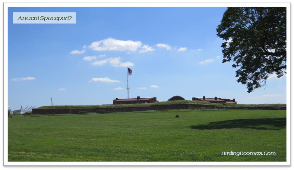
As of late and over the past six weeks or so while I have been healing from an injury to my right shoulder, I find that I am watching quite a bit of television as one is apt to do when one is recovering from something or another. And it turns out that one of my favorite shows (lately) is Ancient Aliens on the History Channel. If you are familiar with the show, you will know that it explores the possibility that the earth was visited by extraterrestrials in ancient times (pre-history) who influenced (sometimes good and sometimes bad – mostly just meddling in) the development and history of mankind. So, as I strolled around the park at Fort McHenry I couldn’t help but be struck by the star-shape of the design of the fort and I began to wonder about things celestial as I wandered about the place.
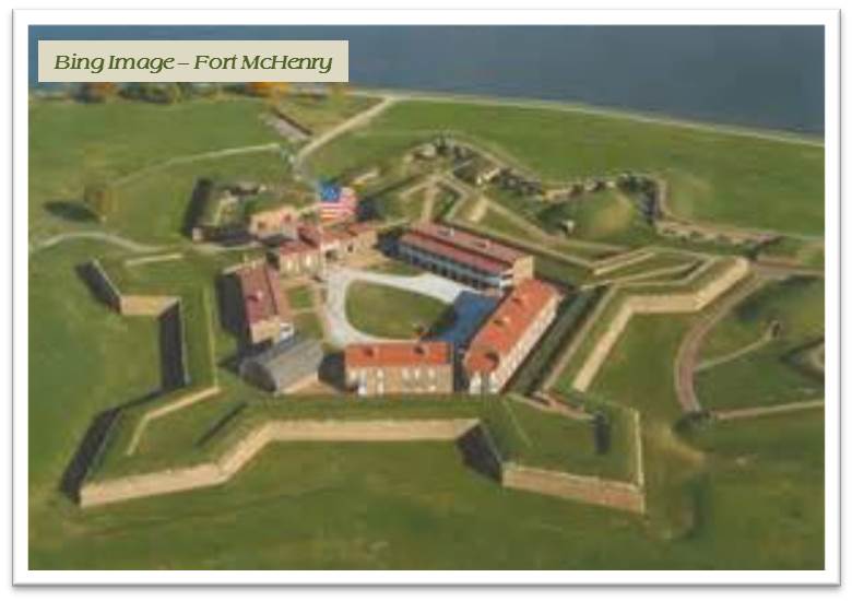 So let’s talk about the shape of things at Fort McHenry. Here we have a perfectly shaped 5-pointed star that can really only be appreciated or fully viewed from above. So, it stands to reason that it was built by someone or something (maybe terrestrial or, then again, maybe celestial) who could see the whole site from the air or maybe even from space. Right – just like the Nazca Lines in Peru. After all, there were barely even balloons in 1789 when Fort McHenry was built let alone flying vehicles that could have properly surveyed the site from the air. (Although I will note that one Benjamin Franklin was somewhat into flying kites or so we have been told but I wonder where exactly he got his ideas about electricity! Do you think he might have been an alien?)
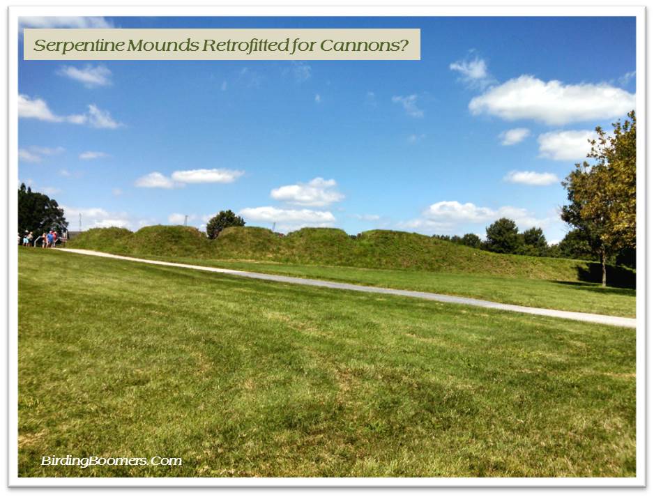
 So we have a five-pointed star but looking at the maps and charts in the museum on site, I discovered that the shape was actually a five-pointed star built on what looked like another partially obscured or busted up star with some sort of arrow right through the middle of it. You guessed it – the original buildings on the site must have represented the home universe for the extraterrestrials who visited Baltimore in ancient times before it was called Baltimore and had some sort of native name like “place of the blue crabs that are steamed with Old Bay but not boiled”. If you study star charts, you will no doubt find a solar system with an earth-like planet in a binary star system with one fully active vibrant sun and a second sun that is a dying. The extraterrestrials who visited this site have thus left clues to their original home so that we could find our way to them in a future when our technology was advanced enough to recognize that particular constellation. Of course, the arrow through the middle of the fort points to the rising sun on the summer solstice in alternate leap years when the moon is in retrograde and Mars is in its perihelion. Yes, the home of our extraterrestrial ancestors is out there somewhere – perhaps in Alpha Centauri or Andromeda.
 But, of course, you might tell me some gobbledygoop about military forts and strategies and that the 5-pointed star design was somehow superior from a military standpoint for the best defense of a given point of land. Or, that any idiot can climb up a tree and see the shape of the fort without ever having to step foot in a spaceship. Or, that the Pentagon is also a five-sided stronghold and no one ever said it was built by extraterrestrials. Hold on – now wait a minute. The Pentagon is five-sided just like a five-pointed star….well, sort of….maybe a stylized star – if you squint your eyes, you can see that right off. And I seem to recall visiting other historical forts over the years like Fort Pulaski near Savannah, Georgia that had five sides too. I’m seeing a trend here. Obviously, these were all sites that had significance to humans throughout the ages even before the US decided to use the sites for military strongholds and built on top of the older prehistoric artifacts and monuments. (Did you like that leap in logic? We’re on a roll now. I just have to figure out how to work Stonehenge into the whole thing.)
 So, we have Fort McHenry sitting on a point that was clearly a sacred site to the Native Americans and clearly the perfect site for a fort to be built to protect the good people of Baltimore. As I walked on the ramparts circling the fort, I could actually sense the sacredness of the site – a faint tingling going up and down my spine. (Okay, it could have been that I’d been in the sun too long or that my ears were ringing from the cannon firing demonstration but there was a tingling, I swear.) And then, it occurred to me that the flag was in exactly the right position just to the center front of the star to be protected and it is no wonder that Frances Scott Key was able to see it in the early hours that fateful morning. It was obviously in a mysterious vortex of some sort of magnetic phenomenon and no cannonballs from any primitive wooden ships would be able to harm it….ever…as long as it was centered in that vortex.
I think it would be just a matter of time before archaeologists discovered the original foundations and remnants of buildings that were built long before the Fort was ever conceived of or built. If there were some big old rocks in Baltimore, I’m sure they would have petroglyphs on them and historians would spend years trying to figure out what they meant and how the stones got there in the beginning. It is absolutely plausible that this was the site of a landing spot for spaceships and vehicles used by extraterrestrials in ancient times. It makes sense in that location right at the top of the Chesapeake Bay. And there are several of these “forts” up and down the east coast that could have been used by the ancient aliens. It is just so clear if you think about it for a moment or two.
And what’s up with that park up the street from Fort McHenry called Federal Hill Park? Right in the middle of this part of the city, there’s a big hill sticking up above the row houses like a green knob. According to one lady that I talked to, this is one of the oldest parks in the US and has been there as long as anyone can remember. It was there long before the colonists arrived and is still there today looking like an Indian mound right there close to downtown Baltimore. It makes sense that there would be a smaller complex near a giant space port like Fort McHenry, now doesn’t it? Do you think there might be tombs inside the hill or maybe a ring of stones at the summit – maybe Baltimore Henge? (See, I got it in there after all.)
Again, no doubt the ancient history could be revealed with further study of the site and more archaeological digs. But, alas, we shall never know because the United States Government has declared these sites to be national monuments that are protected from further study into their origins. What do you suppose they are hiding? And so the mystery will ever remain just that – a mystery….or maybe a Government conspiracy. How shall we ever know?
 Note/Disclaimer: For all you believers out there, you need to know – I just made this last part up – all of it. Okay, the part about the Fort being in the shape of a five-pointed star is true and the Pentagon is five-sided and there is a Federal Hill Park in Baltimore. The part about the alien site at the Fort all originated in my television-saturated mind.