The distance from our home in Maryland to the Outer Banks in North Carolina is roughly three hundred miles as the crow flies or the stagecoach rolls. Driving at about sixty miles per hour (MPH), it should take the average driver just under five hours to reach Kittyhawk on a good day if you make all the lights and don’t stop too long at the Cracker Barrel for lunch. We pride ourselves on being pretty good drivers but I have to admit that, some years back, we made that trip in an unbelievable record breaking time of four and a half days. Amazing! Yep, you read correctly – we took more than four days to get to the Outer Banks from Maryland, the state right next door to North Carolina. And we weren’t even driving a horse and buggy – it was a real car with a speedometer that goes all the way up past a hundred miles an hour. (Yes, I tried to say “miles per hour” but the southern in me just couldn’t keep it up.) No, to answer your question, we did not have any car trouble or flat tires. We just set our usual road trip pace. While others may speed down the interstate like a bat outta hell, we tend to stick to back roads and just meander along at a snail’s pace….or, more precisely, at a pace more fitting to bird watching and just looking around. And by meander, I don’t just mean we drive slowly, we also drive up and down country roads, stop at every possible scenic overlook and visit any and all parks and gardens we might pass on our way. It sometimes takes us hours (and maybe days as in the case with the Outer Banks) to get some place so when we go any place, we have to plan ahead because you see, “time is of the essence”1 with us.
Let me correct that: our traveling takes scheduling, mostly. It takes planning when we’re going somewhere by plane or train or when we need touring assistance. When we head out in the car, what we need is time. Like Harry Chapin, we keep a “watch on time”2 when we have “work to do”2 or a deadline or a train to catch but otherwise, we just go where the car and the GPS takes us. On the other hand, we are not quite in sync with J.R.R. Tolkien’s famous line, “Not all those who wander are lost….”3. Quite often we are, in fact, lost and, we are lost by design.
And so it was that we headed out on the road a few weeks ago. Our “plan” was hatched when my better half volunteered to help out in building a deck at the Global Aid Network (GAiN) warehouse near Mount Joy, Pennsylvania. See, he is the better half since he actually went to work and I had no real intention of helping build that deck. I was just going along for the ride. And, since we need approximately two hours to get from our home in Maryland to the warehouse in Pennsylvania, we gave ourselves one and a half days. It worked out splendidly.
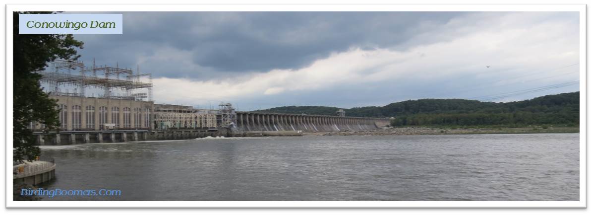 We started out heading for Conowingo Dam on the Susquehanna River at the upper end of the Chesapeake Bay. It is a birding hotspot that every birder in Maryland knows about and visits at least once a year….mostly in winter. The attraction is the Bald Eagles who fish and hunt on the river at the bottom of the dam….again, mainly in the winter. The absolute best place to get information on Conowingo Dam for birding is the blog of an excellent local birding photographer, Emily Carter. I had heard many good things about Conowingo and wanted to scope it out (pun intended, of course) in summer and then maybe go back later in the year. I had heard that there weren’t many Bald Eagles there in summer but there were a goodly amount of herons and gulls that would make the birding interesting so why not? Of course, we couldn’t just get in the car and drive straight there – that would defeat the whole point of giving ourselves all that extra time to meander.
We headed up in that general but, certainly not specific, direction – that is, more or less northeast. It was a beautiful day and we blasted through Baltimore and soon got our first sign to pause. It was one of those brown ones that announce that a state park or historical marker is nearby and couldn’t be more than just a short piece off the main road. The first park-o-the-day was Gunpowder Falls State Park. Nearby was another great find – Marshy Point Nature Center. Two for the price of one – how can you beat that?
 We headed for the Nature Center first and, as is the way with these things sometimes, the road signs led us first one way and then the other until we found ourselves very close to where we had actually turned off the main highway. It felt sort of like a Dr. Seuss story or was it The Hobbit who went “There and Back Again”4? (Yep, I’m back with Tolkien). The Nature Center was lovely but we pulled in behind a school bus filled with children (pre-teens maybe). Now, there is nothing I like more than knowing young’uns are getting out into nature and learning all that they can about birds and bugs and wildflowers but, on the other hand, there is nothing I like less than trying to bird in a park filled with noisy yakking kids running around with butterfly nets and clipboards. Well……nothing except people walking their dogs and letting them off the leash to run free. Don’t get me started on this one. So, we looked around a bit and left the nature center to the kids and moved on to the state park – which was lovely and big and relatively kid-less.
 There is a small cost for entry ($3) but well worth it to visit the park and enjoy all the amenities. It is big enough (maybe 18,000 acres) to handle several busloads of kids without noticeable impact. There is a beach for swimming, meadows for playing, a boat launch for cruising and fishing, rails-to-trails hiking, and a few good habitats (waterfront, streams, marshlands, woods, meadows, etc.) for birding. But there weren’t many birds to be seen this day. We did find an area that was relatively birdy on Graces Quarters Road over by the marina and boat launch – at least it sounded that way because we heard lots of birds singing but didn’t see too many willing to show themselves to us. (DNR Guide to Gunpowder Falls State Park)
Whatever – on to the next place – lunch! I discovered that the upper parts of Maryland and lower parts of Pennsylvania are filled with silver diners. Oh, the names are different but these restaurants are all the same – big silver metal sided buildings with lots of parking and lots of menu selections inside. Lunch is good.
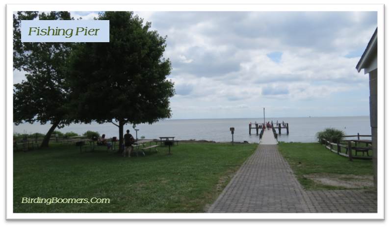
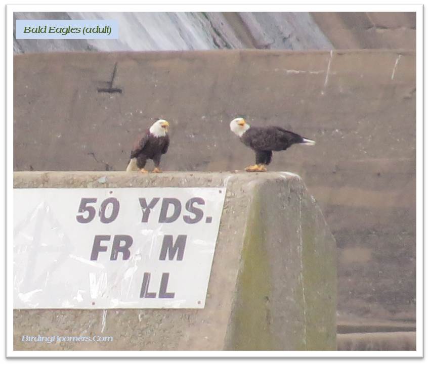
 Then it was on to Conowingo. The Dam is off the main road a bit but easy to find and easy to access. Although birders go there often, I had wondered how easy it would be to get there and if you would have to walk a good distance to get to the best spot for seeing the eagles. While it is true that you cannot get too close to the Dam itself – way too dangerous, there is a small park open to the public called the Fishing Pier with paved parking and several options for viewing the river and the birds and fishing, of course. Emily’s blog had advised that one should park by the porta potties to see the eagles fishing near an island in the river and possibly landing in the trees to eat their catch. Emily’s advice was to move up closer to the Dam to see eagles fighting and scuffling away from the trees. Her advice was good. I think the biggest problem in the winter might be standing around in the cold weather not to mention competing with the number of birders and photographers who come and take up the choice viewing spots and parking spaces…and using porta potties. In the summer, you do not have these problems except for the porta potties part. We found a few photographers set up near the “island view” but there were plenty of vacant parking spaces and several available picnic tables. We also headed up near the dam (easy walking and a short distance so we could have walked) and parked near the ramp going down to the area that seemed to be preferred by the fishermen of which there were plenty. And they seemed to be catching quite a few fish.
 There were tons of gulls and cormorants near the dam. They were easily viewed with binoculars but a more powerful scope would have been better for making precise identifications or looking for the rare ones. There were quite a few Great Blue Herons – I stopped counting at twenty-five (25). And the island was completely swamped with Black and Turkey Vultures. But there were not so many bald eagles….as expected. We did see about five (5), maybe ten (10)…..most were juveniles who didn’t have full adult plumage. But they were all beauties and put on a pretty good show – a little fishing and a little fighting. Alas, the distances were too much for my small camera. I think that on future visits, I will take Emily’s advice and rent a camera with a big ole long lens that can spot a flea on a skunk’s back from over half a mile.
 We stayed at Conowingo for a couple hours and then headed into Pennsylvania and up towards Lancaster. You know, I have been to Lancaster many times in the past and I thought I knew it relatively well. But it turns out; I had only passed near Lancaster visiting the Amish markets out in the country and had never gone into the city at all. Our trustworthy GPS remedied that situation right away. Everywhere we tried to go, the GPS directed us right back through Lancaster….but not the same part of Lancaster every time. I did not know there could be so many one way streets within a two block radius of a city…. outside of Washington, DC, that is. But we managed to find them all, every single one of them, along with a couple streets that were closed for construction that our dear “Road Witch” did not seem to know about. It’s a pretty neat city though with lots of row houses that reminded me very much of Baltimore and Philadelphia.
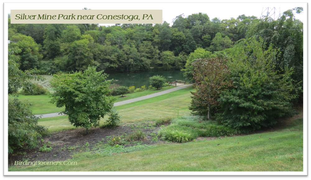 But we did manage to find a couple parks to explore – Longs Park which was more of a family oriented recreational park with a few domestic ducks but no birds otherwise – and a great little park called the Silver Mine Park near Conestoga outside of Lancaster. This last park was big, included several different habitats that would be great for birding, walking trails, and natural water sources – creeks and ponds. But best of all, the park had benches along the walking trail. I am big on benches in parks. They allow you to rest when you get tired and to sit and let the birds find you which they are apt to do once everyone settles down and stops making so much noise. We did meet one gentleman walking there who told us that, yes, there was an old silver mine on the property and they (the parks service?) used to give tours of the mine until it got too dangerous. Now you can hike near the mine but cannot go in to explore. What with the price of silver these days, I wonder that no one has decided to sneak in and find out if any silver remains down deep in the mine and ready to be appropriated.
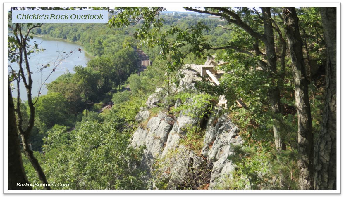 We managed to find several other great parks that would be good for birding but we did not see too many birds. Maybe the heat had forced the birds deep into the woods but we saw very few along the areas we explored. We did take a relatively long and difficult (rocky) hike up to Chickie’s Overlook near Colombia where we were treated to great views of the Susquehanna River and a couple of little birds I think were Pine Warblers. The markings seemed good for Pine Warblers and they were certainly feeding in a couple pine trees but they just wouldn’t cooperate by being still long enough for me to get a good picture that I could check against the guides later when I got home. They did match the info in my mobile apps so I’m going with the call. These two birds were about the best sighting of the trip….okay, except for the Bald Eagles…and the Herons…and the Cormorants. Yep, they are all the “best” for me……even the Vultures.
 But, all in all, what with all the meandering and looking around, the “best” birding I did was at the GAiN site. While the men worked on building the deck, I listened to an audio book and did a little casual birding of the fields of corn and the farmer’s house nearby. I saw mostly yard birds – nothing rare or unusual – but the birds I saw were entertaining and beautiful as always. And, that’s enough for me on any given day. The Blue Jays and Cardinals and Chickadees reminded me of the birds at home – waiting patiently for us to return from our meandering and head on back down the road to home and the important stuff – like keeping those feeders full of good black oil sunflower seeds, millet, and safflower.

The full quote from J.R.R. Tolkien:
“All that is gold does not glitter,
Not all those who wander are lost;
The old that is strong does not wither,
Deep roots are not reached by the frost.
From the ashes a fire shall be woken,
A light from the shadows shall spring;
Renewed shall be blade that was broken,
The crownless again shall be king.”3
References:
- Anonymous phrase. [I looked it up but no clear person or source could be identified for this commonly used phrase.]
- “Let Time Go Lightly” (Lyrics); Greatest Stories Live (Album); Harry Chapin; 1976; Elektra. [Youtube Audio/Video Link – http://www.youtube.com/watch?v=2Gvhkr3v8iU ]
- The Fellowship of the Ring; J.R.R. Tolkien; United Kingdom; George Allen & Unwin (publisher); UK; July 29, 1954.
- The Hobbit There and Back Again; J.R.R. Tolkien; United Kingdom; George Allen & Unwin (publisher); UK; September 21, 1937