If you missed Days 1 – 3 of this series, you can catch up here (NE Day 1, NE Day 2, and NE Day 3).
I suppose you could subtitle this blog “wandering around Kearney and Gibbon” because that is pretty much what we did. It was not exactly a rest day but it was a day betwixt and between that was not filled with miles we had to travel to get from one place to the next and there were no reservations or appointments we had to keep.
 There were a few places we wanted to visit along the river which seemed to be a hotspot for state recreation areas and wildlife management areas (WMA’s). Since I wasn’t really sure about the dates for hunting season in Nebraska and WMA’s are usually more rustic in terms of access roads, we elected to check out the SRAs and do a little more birding around Rowe Sanctuary.
First stop of the day? We had previously noted the large ponds/impounds out back of the hotel and decided to check them out. The site looked like a sand dredging complex with a look of industrial activities – lots of trucks and gated roads. It didn’t hurt that we had seen large flocks of Snow Geese from the window of our room and it seemed only right that we check out these birds on our way out this morning.
 So, we headed out back, through a parking lot, down an access road, past the hockey arena and over towards the ponds and the geese. We were not disappointed. There was a large flock of Snow Geese interspersed with Canada Geese, a scattering of Red-Winged Blackbirds, and a few Killdeer. The highlight was getting close looks at several grey or blue morph Snow Geese. Not bad birding and a good start for the day. You just never know where a birding hotspot is going to be. Birds are sometimes in the most unlikely of places and not always in the preserves and refuges where you would expect them to be….although what goose can resist a good pond in the morning?
 Then it was back onto Interstate 80 and heading up to Gibbon. You may recall that Gibbon is where Rowe Sanctuary is located – well, close to Gibbon since it is rare to find a wildlife sanctuary inside a town. As you can imagine, we never really saw Gibbon and I’m not sure it was more than just a small country community. But we did spend some time at a few places outside the town.
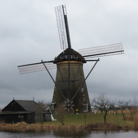
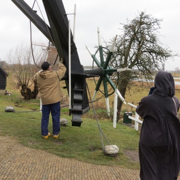
Our first stop was…well, second after the ponds beside the hockey arena….. Windmill State Recreation Area (SRA).
According to the guides and the parks website, Windmill SRA was supposed to have something like eighteen (18) old windmills that have been restored to working order and on display in the park. This sounded like something I wanted to see and Jerry was good with it. After all, what red-blooded male doesn’t want to see oversized mechanical things whirling and clacking and grinding away at something? Otherwise, the park provides camping facilities and walking paths and recreational facilities along a string of lakes that are located right alongside Interstate 80.
The site was originally known as Windmill Crossing and was the location that the Pawnee Indians used to ford the river on their annual buffalo hunts. I’m not sure why the Pawnee Indians would name a river crossing after a windmill since I’m not sure they were known for using windmills….so I suspect the name came later from the area’s use as a stopover for pioneers moving along the Mormon or Oregon Trails. Perhaps, a windmill had been erected to pump fresh water from one of the lakes. Who knows? All right – maybe the Pawnee were big on windmills.
 At any rate, the oldest windmill was supposed to be an 1880 Standard that was moved down from Fleming, Colorado where it had previously been used to pump water for steam locomotives. Since we only found two (2) windmills in the park (how can you miss something as big as a windmill?) and I have no idea which is the Standard model, I will post the photos and you can decide for yourself.
Overall, the park was a nice one and the lakes still had a few Scaups that had not yet migrated north. Our most exciting bird encounter involved the Sandhill Cranes. The guides at Rowe had told us that the warm sunny weather predicted for the next few days would be ideal for the Cranes to start the next phase of their migration. We had been advised to watch for the birds kettling using the northwest winds to aid them on their journey. For those who are not familiar with the term “kettling”, it is a term for the activity some birds do whereby they fly in a circular motion in large groups moving ever higher into the sky allowing them to catch the thermal updrafts and save energy as they prepare for migration.
 Per the explanation for a kettle at Wikipedia, the term may be derived from a location near Hawk Mountain, Pennsylvania called “the Kettle” or “der Kessel” in Pennsylvania Dutch where hawks, eagles and other raptors are known for such behavior. Others say that the term comes from the idea that the birds flying in a circle gives the appearance of being in a pot of boiling water…or, in this case, a swirling vortex of warm air. At any rate, we were thrilled to see hundreds, if not thousands, of Sandhill Cranes kettling overhead just as we drove into the park. It was beautiful….we stopped right there in the road (hey, it’s a park and there was no one about), jumped out of the car and stood there for at least 30 minutes totally amazed at the spectacle. The birds had started low and flew higher and higher until they were totally lost in the vastness of the beautiful blue sky. We wished them well on their journey and then continued on our own journey.
Besides the Cranes and the aforementioned Scaups, there were Red-Winged Blackbirds, Common Grackles, a Collared Dove, a couple Canada Geese, two beautiful Northern Flickers, and the ever plentiful American Robins. We had not gone anywhere in Nebraska that we did not see lots of Robins….they were literally everywhere. After a couple days, we started to get a little concerned if we didn’t see a mess of robins at every place we stopped.
After exploring the SRA, we headed outside the gates to Fat Jack’s or something like that where we took a much needed bathroom break, got gas for the car, and found, to my delight, freshly popped popcorn for sale. Of course, I got a big bag…who wouldn’t?
 Then it was over the Interstate and back to Audubon’s Rowe Sanctuary where we bought the T-Shirt as one must when one travels to new places. How else do you say that you’ve been there and done that if you do not buy the T-shirt…or other such trinkets? We chatted with the volunteers there who gave us all the scoop on the joys of volunteering at the site and how we should volunteer should be ever be looking for something to do in March and April in some future year. While there is no pay for the job, the Sanctuary does provide lodging for the volunteers during the time they volunteer each season. Although it is pretty cold in Nebraska in March, it might not be a bad deal to consider going on a “Crane” holiday one year in the future.
Although portions of the Sanctuary were closed during the Crane migration and hiking was limited, we had noticed a road (dirt, of course) running past the Visitor Center and off into the countryside through parts of the Sanctuary so decided to explore it. After all, we’re the meandering kind and there’s nothing lovelier for birding than a good dirt road on a warm sunny day. We were rewarded right off the bat when we discovered lots of fields filled with lots of Sandhill Cranes. Then there was a great farmer’s pond with Blue-Winged Teals and Ruddy Ducks. And, if you have a pond and field with birds, you’re gonna see a Hawk or two doing a little hunting.
 Roaming on down the road, we were totally delighted to find a Ring-Necked Pheasant strutting across the field obviously trying to catch the attention of some female we could not see. As we came to a bend in the road, we spotted a Western Meadowlark perched on the “curve” sign singing his heart out….just a lovely day altogether.
 Towards the far backside of the Sanctuary property, there is a small creek that empties into the river that attracts waterfowl and cranes. A vehicle pull-off with a blind has been built there by the road that makes a great spot for watching the birds on and around the water. Why hadn’t the staff at the Visitor Center mentioned this great spot?
 It was marvelous and we spent a little time there before moving on down the road…..and more road and more road…all of it dirt.
Bird sightings dwindled so I entered the next SRA into the GPS and we were on our way to Fort Kearney SRA which turned out to be a nice camping area with a few small ponds and a good biking trail but not too many birds (of course, it could be the time of day – afternoon – was not really good for birding)…but there were plenty of robins, if nothing else.
 Next stop – Fort Kearney Historical Park which was really small and just about what you’d expect – a good park but devoted more to historical events in the area than birding. There was a small museum there but we opted not to check it out. It was late and we were hungry so we headed back to the hotel…which turned out to be just a few miles away. Turns out we had circled back around from the Gibbon area to Kearney in our meandering along the back roads. We got lunch, took a quick break, and headed to our third – maybe fourth – stop of the day.
 The Great Platte River Road Archway is a large museum spanning Interstate 80 which commemorates the movement of the pioneers along the various trails (Mormon, California, Oregon, etc.) and the building of the Lincoln Highway (Route 30/Interstate 80) across the west. For those who like such things – the Archway weighs 1,500 tons, spans 308 feet across the highway, includes about 79K square feet, sits 30 feet above the roadway, includes 24 mannequins based on the faces of real people, covers about 170 years of history, and cost about $60M to build. Besides us, other noteworthy VIP’s who have visited the museum include President Bill Clinton who visited in December 2000.
 The museum had been recommended to us as a neat place to visit and very interesting….not that the fact that it spanned the highway wasn’t incentive enough…so we decided to give it a go. The museum was not crowded on this afternoon….well, I think we might actually have been the only visitors at the moment we entered the building although there were some folks looking around outside. Since I’m not crazy about crowds, it was ideal.
 We were met at the door by docents dressed in pioneer costumes and pointed to the ticket window to get tickets and listening aids for the programmed guided tour and then we headed up the escalator and started the tour.
It was an interesting tour and museum in that it wasn’t your typical museum with loads of artifacts and antiques to see and learn about. Rather, it was more experiential in that displays were set up like dioramas. You clicked on the display number on your listening device and the speaker would explain the display to you. It was time-consuming and took way more time that I thought was needed but we did learn quite a bit about the early pioneers and travelers along the trails and the Lincoln Highway.
 Let me take a moment and give one story that goes along with the photo I’ve included showing a statue of two children speeding off on a horse. It seems that these two young boys, the Martin Brothers, are very well known in the history of the area. In the Indian uprising in 1864, George Martin and his two sons were working in the fields loading hay when they were attacked by a band of Sioux Indians. As the father tried to fight off the Indians, the two boys jumped on a horse, riding double, and headed home. As the boys fled the scene, one of the Indians fired an arrow at them. The arrow passed through Nat’s body and lodged in Robert’s back….knocking both boys off the horse. The Indian, thinking they were pretty much dead, did not bother to check further and so, fortunately, did not scalp them. Both boys survived although Robert never recovered from the back injury. Per the reports, Nat lived to tell the story of his escape to his grandchildren.


After the museum, it was nap time at the hotel. What else?
 Before supper, we did a little birding in a neighborhood near the hotel. Grandpa’s Steak House, sadly, is no longer in business but it lives forever as a hotspot on eBird and it warranted our checking it out. There was a small lake behind the former restaurant which explains the eBird connection. It would have (and probably still does) attracted waterfowl during the winter. We did spot Snow and Canada Geese there along with a Collared Dove or two and a couple of House Sparrows that have made a nice nest behind one of the large white letters on the building’s façade. We rode through the neighborhood by the lake, spotted a few Northern Shovelers, and then encountered a Wild Turkey strutting through the neighborhood as we drove out through the community gate.
Afterthought: A few things we have discovered that Nebraska doesn’t have so far –
Vultures – we have not spotted a single vulture, neither black nor turkey since we arrived in the state. So who cleans up roadkill?
Crows – maybe we’ve seen two…..all those corn fields and no crows?
Osprey – the guide at Rowe Sanctuary said he had never heard of Ospreys when we asked about the birds.
And, of course, no Canada Dry Ginger Ale as I mentioned in a previous blog in this series.
Itinerary:
April 3 – Baltimore, MD to Omaha, NE (via Minneapolis, MN): 1153 Miles
April 4 – Omaha to Grand Island (via Route 30): 160 Miles
April 5 – Grand Island to Kearney (via Interstate 80): 49 Miles
April 6 – Meandering around Kearney and Gibbon (Interstate 80 and the Back Roads)
Sites Visited Thus Far:
ADM Grain Company Driveway (Day 2)
Audubon’s Rowe Sanctuary (D3 & D4)
Crane Trust (D3)
Eagle Scout Park (D3)
Fort Kearney Historical Park (D4)
Fort Kearney State Recreation Area (SRA) (D4)
Freemont State Recreation Area (SRA) (D2)
Grandpa’s Steak House (D4)
Great Platte River Road Archway (D4)
Higgins Memorial (D2)
Mormon Island State Recreation Area (SRA) (D3)
Townsley-Murdock Trail Site (D2)
Windmill State Recreation Area (D4)
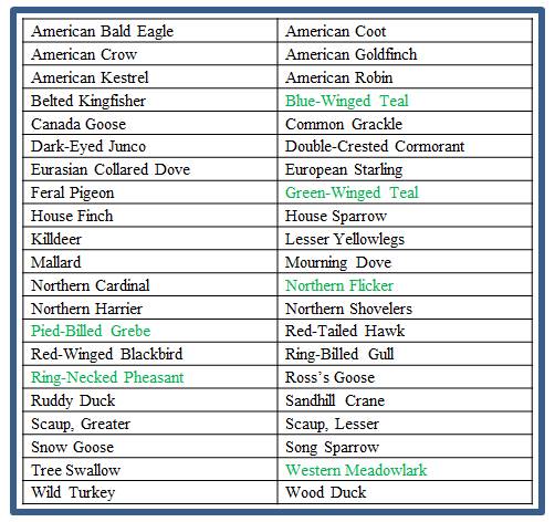
Birds Spotted On The Trip Thus Far – Total Species Identified – 42: